Netrakona : A place of PEACE : সুন্দর নেত্রকোণা
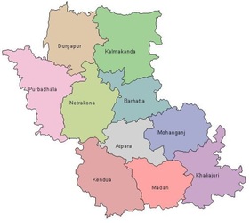
Our NETRAKONANetrakona or Netrokona District (Dhaka division) with an area of 2810.40 km sq km, is bounded by Garo Hills of Meghalaya (India) on the north, Kishoreganj district on the south, Sunamganj district on the east and Mymensingh district on the west. Administration Netrokona subdivision was established in 1882 and was turned into a district in 1984. The district consists of 10 upazilas, 5 municipalities, 45 wards, 102 mahallas, 85 union parishads and 2281 villages. The upazilas are Atpara, Barhatta, Durgapur, Khaliajuri, Kalmakanda, Kendua, Madan, Mohanganj,Netrakona Sadar and Purbadhala; Municipalities are Barhatta, Durgapur, Mohanganj, Kendua and Netrokona Sadar.
________________________________________________ |
Please CLICK above for more information about the history of Netrakona.
Courtesy by : Netrakona-r-alo
|
Netrakona Town (for detail - click here)This is a small calm town with 9 wards and 33 mahallas. Netrakona Pouroshaba was established in 1887 and administration of Netrakona Sadar thana was established in 1874. It was turned into an upazila in 1983. It is a municipal town with an area of 21.02 sq km with a population of 86,541. Among them male are 51.22%, female 48.78%. The density of population in the town is 3951 per sq km and the Literacy rate among the town people is 54.2%.
|
